

The region is defined from 40°W - 80°W and 25°S - 10°N.
As part of the Sense4Fire project, fuel and fire emission products were made available for the Amazon/Cerrado, southern Africa, the eastern Sahel, southern Europe, and a test area in Siberia. The datasets involve the use of different input datasets for burnt area and different configurations of the GFA-S4F, TUD-S4F and KNMI-S5p approaches. Below you find an overview about the Sense4Fire datasets, and a list of all available output variables.
If you want to use the datasets and you are unsure which one to use, please get in contact with Matthias Forkel.
Browse the full folder structure of all datasets.
The Sense4Fire datasets were delivered in different versions of the database:
- Database version 4 (DBv4): Near-real time and high-resolution emissions for Africa. The fourth version of the Sense4Fire database provides advanced methodologies for two study regions in Africa, namely southern Africa and the Sahel. DBv4 provides refined setups of GFA-S4F and TUD-S4F to provide fire emission estimates with low latency, i.e. as provisional (PRV) analysis up to the previous year or as near-real time (NRT), here defined as providing fire emission estimates with a latency of <1 month. In addition, DBv4 includes an unprecedented high resolution fire emission dataset based on the TUD-S4F approach with a high spatial resolution (HR, 20 m). The datasets of DBv4 were published during 2026.
- Database version 3 (DBv3): In 2024, the Amazon experienced an exceptional extreme fire season. During this season, the Sense4Fire project provided updates of fire emissions from the GFA-S4F and TUD-S4F approaches. The purpose of DBv3 – published consecutively during the second half of 2024 – was to demonstrate the near-real time capabilities of the Sense4Fire approaches in providing estimates of fire emissions. Results are available for the Amazon/Cerrado study region for the year 2024 and were published in 2024 DBv3 forms the foundation of the results published in de Laat et al. (2026).
- Database version 2 (DBv2): The Sense4Fire baseline. The second version of the Sense4Fire Database was published in October 2023 with results for the Amazon/Cerrado, southern Africa, Europe, and Siberian study regions. For TUD-S4F, the products and factorial experiments in DBv2 are the baseline products for all study regions. The results for the Amazon/Cerrado study region in DBv2 are the results published in Forkel et al. (2025).
-
Database version 1 (DBv1): Initial developments. The first version of the Sense4Fire Database was made available in May 2023 and provided the first products for the Amazon, southern Africa, Europe, and Siberian study regions. The KNMI-S5p dataset remains the same in version 02 of the Experimental Database. The GFA-S4F datasets for southern Africa, Siberia and Europe remain the same in version 02 of the database. The highly experimental TUD-S4F datasets in DBv1 are deprecated. Users should refer for TUD-S4F results in DBv2.
Amazon and Cerrado
| Database | Approach and setup | Temporal coverage | Use/description in publication | Description |
| DBv30 | TUD-S4F-vNRT01 | 2024 | de Laat et al. 2026 | Initial near-real time setup based on a machine learning model trained against TUD-S4F-v02-S4Fba |
| DBv30 | GFA-S4F-v02 | 2024 | de Laat et al. 2026 | GFA-S4F with improved parametrization for NOx emissions, near real time update for 2024 |
| DBv20 | TUD-S4F-v02-S4Fba | 2020 | Forkel et al. 2025, ATBDv3, PVRv3 | Default TUD-S4F setup in DBv2 with ESA CCI land cover and GFA-S4F burnt area for the year 2020 (FireCCI51 for the other years), dynamic emission factors |
| DBv20 | TUD-S4F-v02-fixEF | 2020 | Forkel et al. 2025, ATBDv3, PVRv3 | Like TUD-S4F-v02-S4Fba but with fixed emission factors |
| DBv20 | TUD-S4F-v02-F51 | 2014-2021 | Forkel et al. 2025, ATBDv3, PVRv3 | Default TUD-S4F setup in DBv2 with ESA CCI land cover and FireCCI51 burnt area for 2014-2021, dynamic emission factors |
| DBv20 | GFA-S4F-v02 | 2019-2023 | Forkel et al. 2025, ATBDv3, PVRv3 | GFA-S4F with improved parametrization for NOx emissions and prolonged time series (2019-2023) |
| DBv10 | KNMI-S5p-v01 | 2020 | Forkel et al. 2025, ATBDv3, PVRv3 | Top-down estimates of CO and NOx emissions using the beta-method |
| DBv10 | GFA-S4F-v01 | 2020 | Andela et al. 2022, ATBDv3, PVRv3 | Original GFA-S4F approach based on Andela et al. (2022) |
Near-real time analysis of the Amazon 2024 fire season (Database version 3, DBv3)
The Amazon experienced an exceptional extreme fire season in 2024. During this season, the Sense4Fire project provided updates of fire emissions from the GFA-S4F and TUD-S4F approaches. The purpose of DBv3 – published consecutively during the second half of 2024 – was to demonstrate the near-real time capabilities of the Sense4Fire approaches in providing estimates of fire emissions. Results are available for the Amazon/Cerrado study region for the year 2024. DBv3 forms the foundation of the results published in de Laat et al. (2026).
Southern Africa
The region is defined from 10°E – 30°E and 5°S – 25°S.
| Database | Approach and setup | Temporal coverage | Use/description in publication | Description |
| DBv40 | TUD-S4F-v03-S211 | 2017–2025 | ATBDv4, PVRv4 | Default TUD-S4F setup in DBv4 with new representation of surface live woody vegetation, ESA WorldCover as land cover and burnt area from high-resolution Sentinel-2 data (Sense4Fire-FireCCIS211 burnt area dataset 2017–2025) |
| DBv40 | TUD-S4F-v03-S311 | 2014–2024 | ATBDv4, PVRv4 | Default TUD-S4F setup in DBv4 with new representation of surface live woody vegetation, ESA WorldCover as land cover and burnt area from medium-resolution MODIS (FireCCI51 2014–2018) and Sentinel-3 (FireCCIS311 2019–2024) data |
| DBv20 | TUD-S4F-v02-S4Fba | 2020 | ATBDv3, PVRv3 | Default TUD-S4F setup in DBv2 with ESA CCI land cover and GFA-S4F burnt area for the year 2020 (FireCCI51 for the other years), dynamic emission factors |
| DBv20 | TUD-S4F-v02-F51 | 2014–2021 | ATBDv3, PVRv3 | Default TUD-S4F setup in DBv2 with ESA CCI land cover and FireCCI51 burnt area for 2014-2021, dynamic emission factors |
| DBv10 | KNMI-S5p-v01 | 2020 | ATBDv3, PVRv3 | Top-down estimates of CO and NOx emissions using the beta-method |
| DBv10 | GFA-S4F-v01 | 2020 | ATBDv3, PVRv3 | Original GFA-S4F approach based on Andela et al. (2022) |
Sahel
The region is defined from 23°E – 43°E and 3° – 15°N.
| Database | Approach and setup | Temporal coverage | Use/description in publication | Description |
| DBv40 | TUD-S4F-v03-S211 | 2017-2025 | ATBDv4 | Default TUD-S4F setup in DBv4 with new representation of surface live woody vegetation, ESA WorldCover as land cover and burnt area from high-resolution Sentinel-2 data (Sense4Fire-FireCCIS211 burnt area dataset 2017–2025 |
| DBv40 | TUD-S4F-v03-S311 | 2014–2024 | ATBDv4, PVRv4 | Default TUD-S4F setup in DBv4 with new representation of surface live woody vegetation, ESA WorldCover as land cover and burnt area from medium-resolution MODIS (FireCCI51 2014–2018) and Sentinel-3 (FireCCIS311 2019–2024) data |
Southern Europe
The region is defined from 10°W – 29.5°E and 34.5°N – 49°N.
| Database | Approach and setup | Temporal coverage | Use/description in publication | Description |
| DBv20 | TUD-S4F-v02-S4Fba | 2020 | ATBDv3, PVRv3 | Default TUD-S4F setup in DBv2 with ESA CCI land cover and GFA-S4F burnt area for the year 2020 (FireCCI51 for the other years), dynamic emission factors |
| DBv20 | TUD-S4F-v02-F51 | 2014–2021 | ATBDv3, PVRv3 | Default TUD-S4F setup in DBv2 with ESA CCI land cover and FireCCI51 burnt area for 2014-2021, dynamic emission factors |
| DBv10 | GFA-S4F-v01 | 2020 | ATBDv3, PVRv3 | Original GFA-S4F approach based on Andela et al. (2022) |
| DBv10 | KNMI-S5p-v01 | 2020 | ATBDv3, PVRv3 | Top-down estimates of CO and NOx emissions using the beta-method |
Siberia
The region is defined from 132°E - 138°E and 60°N - 71°N
| Database | Approach and setup | Temporal coverage | Use/description in publication | Description |
| DBv20 | TUD-S4F-v02-S4Fba | 2020 | ATBDv3, PVRv3 | Default TUD-S4F setup in DBv2 with ESA CCI land cover and GFA-S4F burnt area for the year 2020 (FireCCI51 for the other years), dynamic emission factors |
| DBv10 | GFA-S4F-v01 | 2020 | ATBDv3, PVRv3 | Original GFA-S4F approach based on Andela et al. (2022) |
| DBv10 | KNMI-S5p-v01 | 2020 | ATBDv3, PVRv3 | Top-down estimates of CO and NOx emissions using the beta-method |
Definition of output variables
The following variables are available from Sense4Fire:
|
Variable |
Description |
Unit |
Type |
Approach |
|---|---|---|---|---|
| e_co | fire emissions of carbon monoxide | g/m² | Emission | GFA-S4F, KNMI-S5p, TUD-S4F |
| e_co2 | fire emissions of carbon dioxide | g/m² | Emission | GFA-S4F, TUD-S4F |
| e_ch4 | fire emissions of methane | g/m² | Emission | GFA-S4F, TUD-S4F |
| e_pm25 | fire emissions of particulate matter 2.5 micron | g/m² | Emission | GFA-S4F, TUD-S4F |
| e_nox | fire emissions of nitrogen oxides | g/m² | Emission | GFA-S4F, KNMI-S5p, TUD-S4F |
| ef_co | emission factor carbon monoxide | g/kg | Emission factor | TUD-S4F |
| ef_co2 | emission factor carbon dioxide | g/kg | Emission factor | TUD-S4F |
| ef_ch4 | emission factor methane | g/kg | Emission factor | TUD-S4F |
| ef_pm25 | emission factor particulate matter 2.5 micron | g/kg | Emission factor | TUD-S4F |
| ef_nox | emission factor nitrogen oxides | g/kg | Emission factor | TUD-S4F |
| mce | modified combustion efficiency | unitless | Combustion efficiency | TUD-S4F |
| bm_wood | woody biomass of trees | kg/m² | Fuel load | TUD-S4F |
| bm_leaf | leaf biomass of trees | kg/m² | Fuel load | TUD-S4F |
| bm_herb | herbaceous biomass (incl. crops) | kg/m² | Fuel load | TUD-S4F |
| bm_slw_wood | woody biomass of surface live woody vegetation | kg/m² | Fuel load | TUD-S4F (>= v03) |
| bm_slw_lead | leaf biomass of surface live woody vegetation | kg/m² | Fuel load | TUD-S4F (>= v03) |
| fwd | fine woody debris (diameter < 7.62 cm) | kg/m² | Fuel load | TUD-S4F |
| cwd | coarse woody debris (diameter > 7.62 cm) | kg/m² | Fuel load | TUD-S4F |
| litter | litter (dead herbaceous and leaf material) | kg/m² | Fuel load | TUD-S4F |
| dmb_total | total dry matter burned (named fc_total before DBv4) | kg/m² | Fuel consumption | GFA-S4F, TUD-S4F |
| dmb_stem | dry matter burned consumption of tree stem biomass | kg/m² | Fuel consumption | TUD-S4F |
| dmb_branches | dry matter burned from consumption of tree branches biomass | kg/m² | Fuel consumption | TUD-S4F |
| dmb_leaf | dry matter burned from consumption of tree leaf biomass | kg/m² | Fuel consumption | TUD-S4F |
| dmb_herb | dry matter burned from consumption of herbaceous biomass | kg/m² | Fuel consumption | TUD-S4F |
| dmb_fwd | dry matter burned emissions from consumption of fine woody debris | kg/m² | Fuel consumption | TUD-S4F |
| dmb_cwd | dry matter burned emissions from consumption of coarse woody debris | kg/m² | Fuel consumption | TUD-S4F |
| dmb_litter | dry matter burned emissions from consumption of leaf and herbaceous litter | kg/m² | Fuel consumption | TUD-S4F |
| dmb_slw_leaf | dry matter burned emissions from consumption of surface live woody vegetation leaves | kg/m² | Fuel consumption | TUD-S4F (>= v03) |
| dmb_slw_wood | dry matter burned emissions from consumption of surface live woody vegetation wood | kg/m² | Fuel consumption | TUD-S4F (>= v03) |
| fmc_live | live fuel moisture content of leaves and herbaceous vegetation | % | Fuel moisture | TUD-S4F |
| fre | fire radiative energy | MJ/m² | Fire | GFA-S4F |
| fire_type | fire types | classes | Fire | GFA-S4F |
| ba_scale | burned area scaling factor | unitless | Fire | GFA-S4F |
Sense4Fire provides two bottom-up fire emission approaches (GFA-S4F and TUD-S4F) and a set of approaches (summarised as KNMI-S5p) to provide a top-down benchmark of estimated fire emissions:
- The GFA-S4F approach is based on the Global Fire Atlas (GFA) algorithm and uses observations of active fires from the VIIRS instrument and of Sentinel-2-derived burnt area maps to provide near-real time estimates of burnt area and performs a mapping of fire types to estimate fire emissions (Andela et al., 2019, 2022a)
- The TUD-S4F approach is a data-model fusion approach that combines several Earth observation products from the Sentinels, from ESA’s Climate Change Initiative (CCI) and from the Copernicus Global Land Service (CGLS) to estimate fuel loads, fuel moisture, fuel consumption, and fire emissions (Forkel et al., 2025)
- KNMI-S5p is a set of approaches that uses observations of atmospheric CO and NOx with Integrated Forecasting Model (IFS) to evaluate bottom-up fire emission estimates. The approaches have been used in Forkel et al. (2025) to evaluate emissions estimates from GFA-S4F and TUD-S4F, among others.
The development of the three Sense4Fire approaches along with their versioning, application to different study regions, and the related deliverables and publications are shown in the Table.
The three approaches are described in scientific publications (Andela et al., 2022a; Forkel et al., 2025; de Laat et al., 2026) and all most recent updates of each approach are described in the Algorithm Theoretical Baseline Document version 4 (ATBDv4)
The GFA-S4F and TUD-S4F approaches are developed to be capable of providing fire emission estimates with low latency, i.e. as provisional (PRV) analysis up to the previous year or as near-real time (NRT), here defined as providing fire emission estimates with a latency of <1 month
|
Approach and version |
Short description |
Related ATBDs, PVRs and IARs |
Study region and temporal coverage Publication |
Related Database |
Data publication date |
|
GFA-S4F-v0.3
|
Based on GFA-S4F-v0.1 but with updated estimation of NRT burnt area based on Sentinel-2 for Africa |
ATBDv4, PVRv4 |
S-Africa 2019-2025 |
DBv4 |
Apr 2026 |
|
Sahel 2019-2025 |
DBv4 |
Sep 2026 |
|||
|
GFA-S4F-v0.2
|
Based on GFA-S4F-v0.1 but with improved parametrization for NOx emissions and prolonged time series (2019-2024) |
ATBDv2.1, ATBDv3, IARv2.1
|
Amazon/Cerrado 2018-2025 |
DBv4 |
Mai 2026 |
|
Amazon/Cerrado 2024 (de Laat et al., 2026) |
DBv3 |
Dec 2024 |
|||
|
Amazon/Cerrado 2019-2023 (Forkel et al., 2025) |
DBv2 |
Oct 2023 |
|||
|
GFA-S4F-v0.1 |
Original description of the GFA-S4F approach based on Andela et al. (2022) |
ATBDv1, PVRv3 |
Amazon/Cerrado, Europe, S-Africa, and Siberia 2020 |
DBv1 |
Nov 2021 |
|
TUD-S4F-v0.3 |
Based on TUD-S4F-v0.2 but with new input datasets and representation of surface live woody vegetation |
ATBDv4, PVRv4 |
S-Africa 2014-2024/2025 |
DBv4 |
Apr 2026 |
|
Sahel 2014-2024/2025 |
DBv4 |
Sep 2026 |
|||
|
TUD-S4F-vNRT01 |
Near-real time setup based on a machine learning model trained against TUD-S4F-v0.2 |
IARv2.1 |
Amazon/Cerrado 2024 (de Laat et al., 2026) |
DBv3 |
Dec 2024 |
|
TUD-S4F-v0.2 |
Default setup of TUD-S4F for all study regions |
ATBDv2.1, ATBDv3, PVRv3, IARv2.1 |
Amazon/Cerrado (Forkel et al., 2025), Europe, S-Africa, and Siberia 2014-2021 |
DBv2 |
Oct 2023 |
|
TUD-S4F-v0.1 (deprecated) |
Initial version of the TUD-S4F approach, replaced by TUD-S4F-v0.2 |
ATBDv1, PVRv2.1 |
Amazon/Cerrado, Europe, S-Africa, and Siberia 2014-2021 |
DBv1 |
Nov 2021 |
|
KNMI-S5p-v0.2 |
Revised setup of the IFS model |
ATBDv4, PVRv4 |
S-Africa, Sahel |
-- (use for validation in DBv4.0/ 4.1) |
Sep 2026 |
|
KNMI-S5p-v0.1 |
Initial description of approach |
ATBDv2.1, ATBDv3, PVRv3 |
Amazon/Cerrado (Forkel et al., 2025; de Laat et al., 2026), Europe, S-Africa, and Siberia 2020 |
DBv1/v2 |
Nov 2021 |
GFA-S4F: near real time fire types and emissions
The GFA-S4F approach introduces an object-based methodology, building on the Global Fire Atlas and Amazon Dashboard (Andela et al., 2019, 2022b), to track individual fires and their characteristics. GFA-S4F makes use of active fire observations from VIIRS. Active fire detections are clustered into fire events using the Fire Atlas algorithm. The size of fire events is then scaled with burnt area from Sentinel-2 imagery to provide realistic near-real time estimates of burnt area. Fire Radiative Energy (FRE) is derived from Fire Radiative Power (FRP) by computing the average FRP over fire duration (i.e. FRP density) and by multiplying with fire duration, providing detailed insights into fire duration and energy release.
Fire types are then estimates by combining properties of indivdiuals fires with land cover information to estimate fire emissions. Fires are clustered into categories like cropland, grassland, savannah, and forest fires.
TUD-S4F: fuels, dry matter burnt and emissions
TUD-S4F is a data-model fusion approach that integrates different Earth observation products such as land cover, leaf area index (LAI), soil water index (SWI), and burnt area within a simple ecosystem model to estimate the spatial patterns and temporal dynamics of biomass, fuel loads and fuel moisture, combustion completeness, fuel consumption, combustion efficiency, emission factors, and fire emissions (Figure). The approach has been introduced and applied in Forkel et al. (2025), which assesses the role of woody debris on fire emissions in the Amazon and Cerrado.
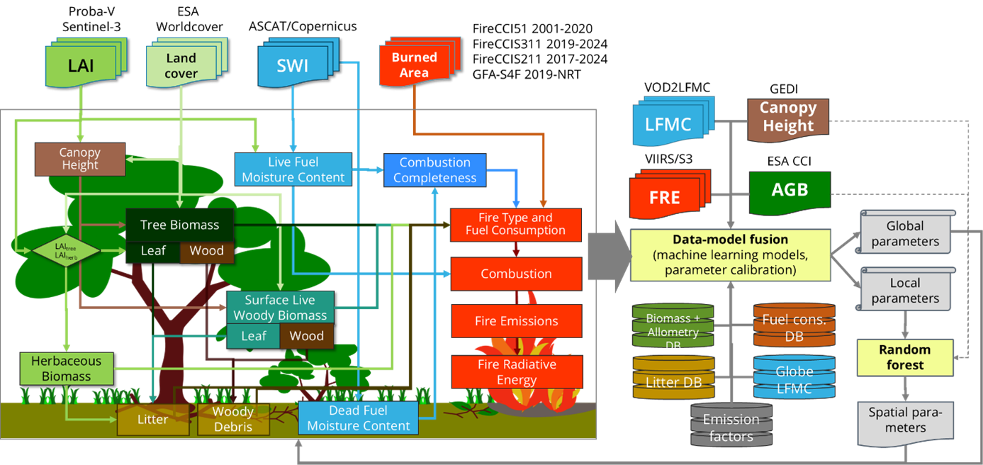
The TUD-S4F core model represents different biomass and fuel components such as tree leaves, branches and stems, herbaceous vegetation, surface live woody biomass (SLW, i.e. shrubs and understorey), surface litter, and fine and coarse woody debris (FWD, CWD). Biomass in trees and SLW vegetation is estimated from canopy height, LAI and land cover using allometric equations that are calibrated based on satellite products of canopy height and above-ground biomass. The accumulation of surface fuels is then estimated from changes in land cover and from seasonal and long-term temporal changes in LAI, which affect the turnover of herbaceous and leaf biomass to litter, and of branches and stems to FWD and CWD, respectively. Fuel moisture content (FMC) is estimated from SWI and LAI for leaves and herbaceous biomass (i.e., live-fuel moisture content, LFMC) and from SWI for live woody biomass. Additionally, SWI is used as a proxy for the dead fuel moisture content (DFMC) of surface fuels. The estimated FMC is then used to estimate combustion completeness.
Unlike in other fire emission inventories, TUD-S4F estimates emission factors dynamically dependent on the chemical composition of biomass and fuel components and fuel moisture by using a chemical-based combustion model. The combustion model is calibrated against field and laboratory databases of emission factors and against satellite observations of fire radiative energy.
KNMI-S5p: top down benchmarking of fire emissions
KNMI-S5p validation approach makes use of Sentinel-5p satellite observations from the TROPOspheric Monitoring Instrument (TROPOMI) of atmospheric composition and air pollution to provide top-down constraints on estimated fire emissions. The advance of TROPOMI has been so important for wildfire emission monitoring and for the first time allows for spatiotemporally detailed a continuous monitoring of wildfire emissions.
The KNMI-S5p approach to use an atmospheric chemistry-transport model as an interface between the wildfire emission estimates on the one hand and the satellite measurements of air pollution on the other hand. Bottom-up wildfire emission estimates – like from GFA-S4F and TUD-S4F – are into the model whose results are collocated with the satellite observations of air pollution. This provides an extensive dataset that can be used to explore how well the model reproduces the observations. Model simulations can be tweaked with other fire emission databases or modifications of those emission databases to bring model results and observations in closer agreement. For the short live trace gas nitrogen dioxide (NO2) the model simulations also allow for applying a post-hoc NO2 emission correction based on the modelled local sensitivity of tropospheric NO2 columns to local NO2 emissions, which has been applied – among others – in Forkel et al. (2025). Assuming linearity between both, that sensitivity – denoted as β-factor – can be multiplied with the differences between model simulated and observed tropospheric NO2 to a local multiplication factor which to first order brings model simulations and observations of tropospheric NO2 in better agreement.
Results in Sense4Fire indicated that CO was a useful addition to NO2. Both traces are emitted by wildfires but have different sensitivities to fire temperatures. Whereas NO2 emissions increase with increasing fire temperature – and thus indicate flaming fires with nearly complete combustion, CO emissions increase with decreasing fire temperatures. CO thus reflects incomplete combustion. The first results of the exploration of the use of TROPOMI measurements for wildfire emission monitoring have focused on short time periods of several months in single year with a focus Amazonia (Forkel et al., 2025; de Laat et al., 2026; other regions were sub-equatorial Africa, Mediterranean Europe and in Siberia).
References
Andela, N., Morton, D. C., Schroeder, W., Chen, Y., Brando, P. M., and Randerson, J. T (2022).
Tracking and classifying Amazon fire events in near real time
Science Advances, 8, eabd2713, https://doi.org/doi:10.1126/sciadv.abd2713.
de Laat, A.T.J., Andela, N., Forkel, M., Huijnen, V., Kinalczyk, D., van Wees, D. (2026).
Sentinel-5p Reveals Unexplained Large Wildfire Carbon Emissions in the Amazon in 2024
Geophysical Research Letters 53, e2025GL115123. https://doi.org/10.1029/2025GL115123
de Laat, A., Huijnen, V., Andela, N., and Forkel, M. (2024).
Assessment of satellite observation-based wildfire emissions inventories using TROPOMI data and IFS-COMPO model simulations
EGUsphere, 1–81, https://doi.org/10.5194/egusphere-2024-732
Forkel, M., Wessollek, C., Huijnen, V., Andela, N., de Laat, A., Kinalczyk, D., Marrs, C., van Wees, D., Bastos, A., Ciais, P., Fawcett, D., Kaiser, J.W., Klauberg, C., Kutchartt, E., Leite, R., Li, W., Silva, C., Sitch, S., Goncalves De Souza, J., Zaehle, S., and Plummer, S. (2025).
Burning of woody debris dominates fire emissions in the Amazon and Cerrado.
Nature Geoscience, 18, 140–147, https://doi.org/10.1038/s41561-024-01637-5
Journal publications
Andela, N., Morton, D. C., Schroeder, W., Chen, Y., Brando, P. M., and Randerson, J. T (2022).
Tracking and classifying Amazon fire events in near real time
Science Advances, 8, eabd2713, https://doi.org/doi:10.1126/sciadv.abd2713.
This publication describes the first version of the GFA-S4F approach.
de Laat, A.T.J., Andela, N., Forkel, M., Huijnen, V., Kinalczyk, D., van Wees, D. (2026).
Sentinel-5p Reveals Unexplained Large Wildfire Carbon Emissions in the Amazon in 2024
Geophysical Research Letters 53, e2025GL115123. https://doi.org/10.1029/2025GL115123
This publication presents the application of the Sense4Fire approaches in near-real time for the extreme fire season in the Amazon region in 2024.
de Laat, A., Huijnen, V., Andela, N., and Forkel, M. (2024).
Assessment of satellite observation-based wildfire emissions inventories using TROPOMI data and IFS-COMPO model simulations
EGUsphere, 1–81, https://doi.org/10.5194/egusphere-2024-732
This preprint presents the first evaluation of fire emission estimates using the KNMI-S5p approach.
Forkel, M., Wessollek, C., Huijnen, V., Andela, N., de Laat, A., Kinalczyk, D., Marrs, C., van Wees, D., Bastos, A., Ciais, P., Fawcett, D., Kaiser, J.W., Klauberg, C., Kutchartt, E., Leite, R., Li, W., Silva, C., Sitch, S., Goncalves De Souza, J., Zaehle, S., and Plummer, S. (2025).
Burning of woody debris dominates fire emissions in the Amazon and Cerrado.
Nature Geoscience, 18, 140–147, https://doi.org/10.1038/s41561-024-01637-5
This paper compares the three Sense4Fire approaches (TUD-S4F, GFA-S4F and KNMI-S5p) with other fire emission datasets and focusses specifically on the role of fuels for fire emissions. A full description of the TUD-S4F approach is given in the Methods and Supplementary Information.
Technical documents
A series of deliverables such as Algorithm Theoretical Baseline Documents (ATBD), Product Validation Reports (PVR) and Impact Assessment Reports (IAR) have been produced in Sense4Fire and published along with the Databases. In order to keep the list of deliverables concise for the potential user of our data products, we list and publish the documents that relate to a certain version of the database.
The fourth version of the Algorithm Theoretical Baseline Document (ATBDv4) provides an updated and complete description of the most recent versions (GFA-S4F-v0.3, TUD-S4F-v0.3, KNMI-S5p-v0.2) of three approaches used in Sense4Fire. The three approaches were previously described in ATBDv2.1 and ATBDv3 (Forkel et al., 2023b, 2024) as well as in the corresponding scientific publications (Andela et al., 2022; Forkel et al., 2025; de Laat et al., 2026). ATBDv4 documents advancements since ATBDv3, reflecting the integration of new Earth observation datasets and methodological developments in the approaches.
|
Technical document |
Content / Relation to Sense4Fire Database |
Date |
Link to document |
| Algorithm Theoretical Baseline Document version 4 (ATBDv4) | Complete description of all approaches used in Sense4Fire, including all updates for Database version 2 (DBv4) | 23.04.2026 | ATBDv4 |
| Product Validation Report version 3 (PVRv3) | Validation results for products published in Database version 2 (DBv2) | 03.05.2024 | PVRv3 |
| Algorithm Theoretical Baseline Document version 3 (ATBDv3) | Update of ATBDv2.1 with description of setups and experiments for all study regions as presented in PVRv3 and for products published in Database version 2 (DBv2) | 03.05.2024 | ATBDv3 |
| Algorithm Theoretical Baseline Document version 2 (ATBDv2.1) | Description of all approaches used in Sense4ire | 05.05.2023 | ATBDv2.1 |
Presentations at conferences and workshops
| Date and event | Presenter | Title and link |
| 23-27 May 2022 | ESA Living Planet Symposium 2022, Bonn, Germany | Jos de Laat | On the use of daily Sentinel-5p trace gas and aerosol observations for characterising small-scale localised wildfires (Presentation) |
| Vincent Huijnen | Using Sentinel-5p trace gas and aerosol observations of fire plumes to constrain a global composition model: a critical assessment (Poster) | |
| Matthias Forkel | Integrating the Sentinels for novel fuel, fire and emissions products to constrain the changing role of vegetation fires in the global carbon cycle (Presentation) (Poster) | |
| Christine Wessollek | Estimating vegetation fuel loads for the quantification of fire emissions by integrating various Earth observation data (Poster) | |
| Niels Andela | Understanding Earth Systems - Tracking Amazon fires in near-real time (Presentation) | |
| 23-28 April 2023 | EGU General Assembly 2023, Vienna, Austria | Matthias Forkel | Effects of land use, fuel loads and fuel moisture on fire intensity and fire emissions in South America derived by reconciling bottom-up and top-down satellite observations (Abstract) (Presentation) |
| Christine Wessollek | Estimating biomass compartments and surface fuel loads by integrating various satellite products with a data-model fusion approach (Abstract) (Presentation) | |
| 14-19 April 2024 | EGU General Assembly 2024, Vienna, Austria | Matthias Forkel | Multiple approaches for quantifying fuels, combustion dynamics, and regional fire emissions in the Amazon and Cerrado (Abstract) (Presentation) |
| Niels Andela | New insights on global fire extremes from object-based fire inventories (Abstract) (Presentation) | |
| Dave van Wees | Comparison and validation of state-of-the-art fire emissions models for the Amazon (Abstract) (Presentation) | |
| 16-18 Sep 2024 | Fire Modelling Workshop; Leverhulme Centre for Wildfire, Science and Society; Dartington Hall, UK | Matthias Forkel | Vegetation-fire interactions: Role of dead wood |
| 19-20 Sep 2024 | 13th EARSeL Forest Fires Special Interest Group Workshop, Milano, Italy | Matthias Forkel | Complementary Earth Observation Approaches to Advance Fire Emission Estimation (Book of abstracts) |
| 26-28 Nov 2024 | Future Focus Wildfires. Community forum; EUMETSAT; Darmstadt, Germany | Matthias Forkel | Sense4Fire – novel fuel, fire and emission products (Presentation) |
| 23-27 Jun 2025 | ESA Living Planet Symposium 2025, Bonn, Germany | Matthias Forkel | Novel Earth observation data-model fusion approaches reveal dominant role of woody debris in fire emissions in the Amazon and Cerrado |
| 21 Jul 2025 | ESA International Workshop on Fire from Space, Harwell, UK | Matthias Forkel | Sense4Fire – Sentinel-based fuel, fire and emissions products to constrain the changing role of vegetation fires in the global carbon cycle |
|
25-26 Jun 2026 | 14th EARSeL Workshop on Forest Fires, Lisbon, Portugal |
Matthias Forkel |
Estimating Fuels and Fire Emissions at 20 m Spatial Resolution in African Savannahs using the S4F Satellite Data-Model Fusion Approach (Poster) |
|
Daniel Kinalczyk |
Estimating Fuels and Fire Emissions in Near Real Time (NRT) in African Savannahs |
|
|
21 Sep 2026 | CBC 2026 Connecting Biodiversity, Climate, and Human Behaviour Conference, Leipzig, Germany |
Matthias Forkel |
Fire, Fuels, and Feedbacks: Uncovering the Role of Vegetation Structure in Amplifying Climate-Driven Wildfire Emissions |
The Sense4Fire project, funded by the European Space Agency (ESA), aims to increase the scientific understanding of dynamics and emissions of landscape fires and their role in the carbon cycle by integrating observations from the Sentinels into new Earth observation products.
Sense4Fire develops novel Earth observation approaches and datasets about fire dynamics and emissions. Fire dynamics encompass a broad range of processes, including pre-fire conditions of the land surface (i.e. fuel loads and fuel moisture), fire behaviour (fire ignitions, spread, speed, size, burnt area, fire type, and radiative power), combustion and production of fire emissions (combustion completeness, dry matter burnt, combustion efficiency, and composition of emissions) and the effect of fire emissions on atmospheric composition.
The Sense4Fire project is part of ESA’s Carbon Science Cluster. The project has been originally funded from August 2021 to July 2023 and has been prolonged twice until December 2026.
-
Datasets
High resolution fuel and fire emissions datasets are available for the Amazon/Cerrado, southern Africa, southern Europe and Siberia. Link to Data
-
Approaches
Sense4Fire provides two fire emission approaches (GFA-S4F and TUD-S4F) and a set of approaches based on Sentinel-5p (KNMI-S5p) to benchmark fire emissions. Link to Approaches
-
Publications
Work from Sense4Fire is published in a series of technical dcouments and in a series of high-level scientific publications. Link to Publications
.
Outreach
-
Vegetation fire dynamics from space
A groundbreaking study, partially funded by ESA, reveals that fire emissions in the Amazon and Cerrado are largely driven by the smouldering combustion of woody debris. This crucial discovery highlights the significant influence of fuel characteristics on fire emissions, with wide-ranging implications for global carbon cycles, air quality and biodiversity.
-
Amazon wildfire emissions up to three times higher than estimated
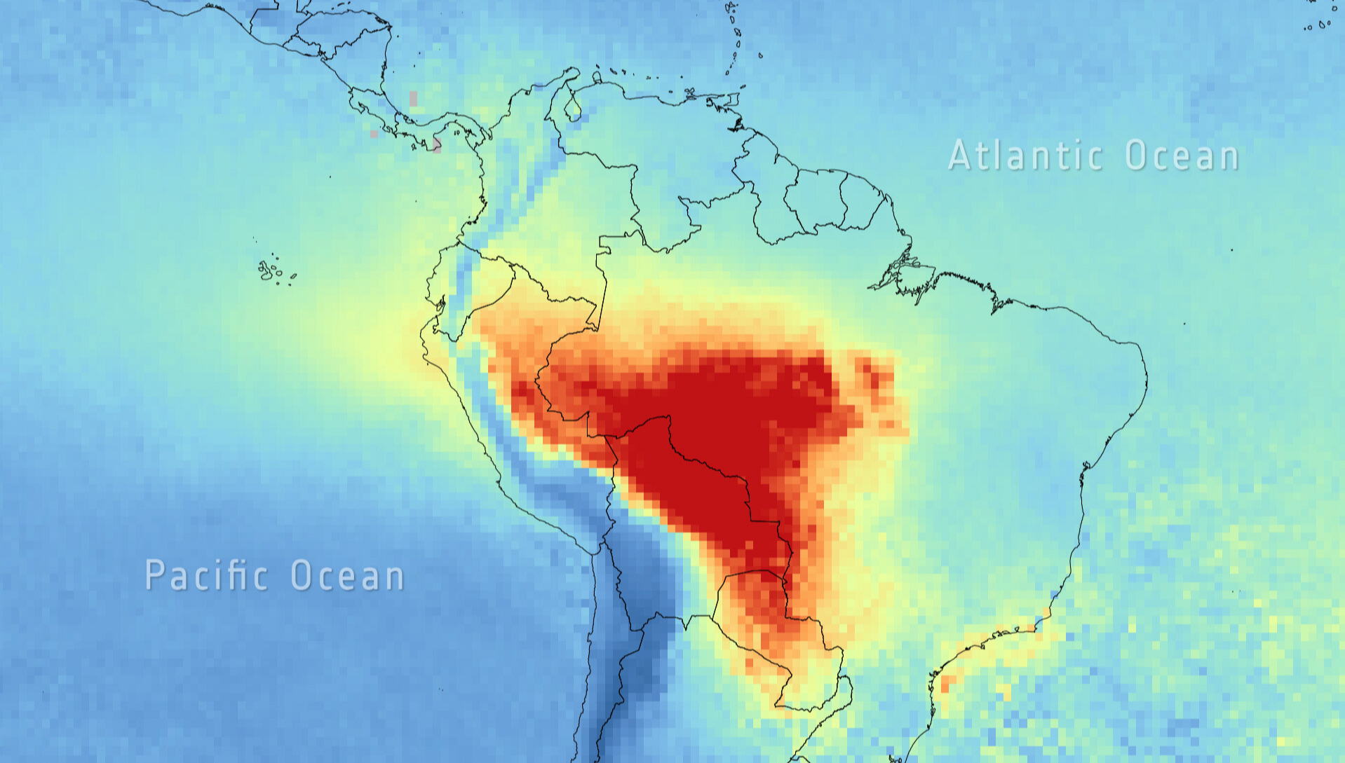
Wildfires that swept across the Amazon in 2024 were the most devastating in more than two decades. New research funded by the European Space Agency (ESA) suggests emissions may have been up to three times higher than earlier estimates.